
Gullah/Geechee Nation Coastal Challenge Update
On the South Carolina Coast: A Tree Saved, a Cultural Overlay Challenged, and Data Centers Given a Path Forward
Monday, September 14, 2026 brought a flood of consequential local-government action along the South Carolina coast. The outcomes were not as simple as “win” or “loss.” The Beaufort County Council did not vote on St. Helena Island’s Cultural Protection Overlay, but the latest Pine Island challenge is moving toward the Planning Commission. In Charleston County, a redesign kept the Sol Legare witness tree standing, but the approved driveway will still enter its critical root zone. In Colleton County, Council did not approve construction of a particular data center; it adopted the comprehensive-plan, zoning-text, and zoning-map changes that make future data centers much easier to permit.
Here is what happened, what did not happen, and what you can do next.
Continuing to uphold St. Helena Island’s Gullah/Geechee Cultural Protection Overlay (CPO)
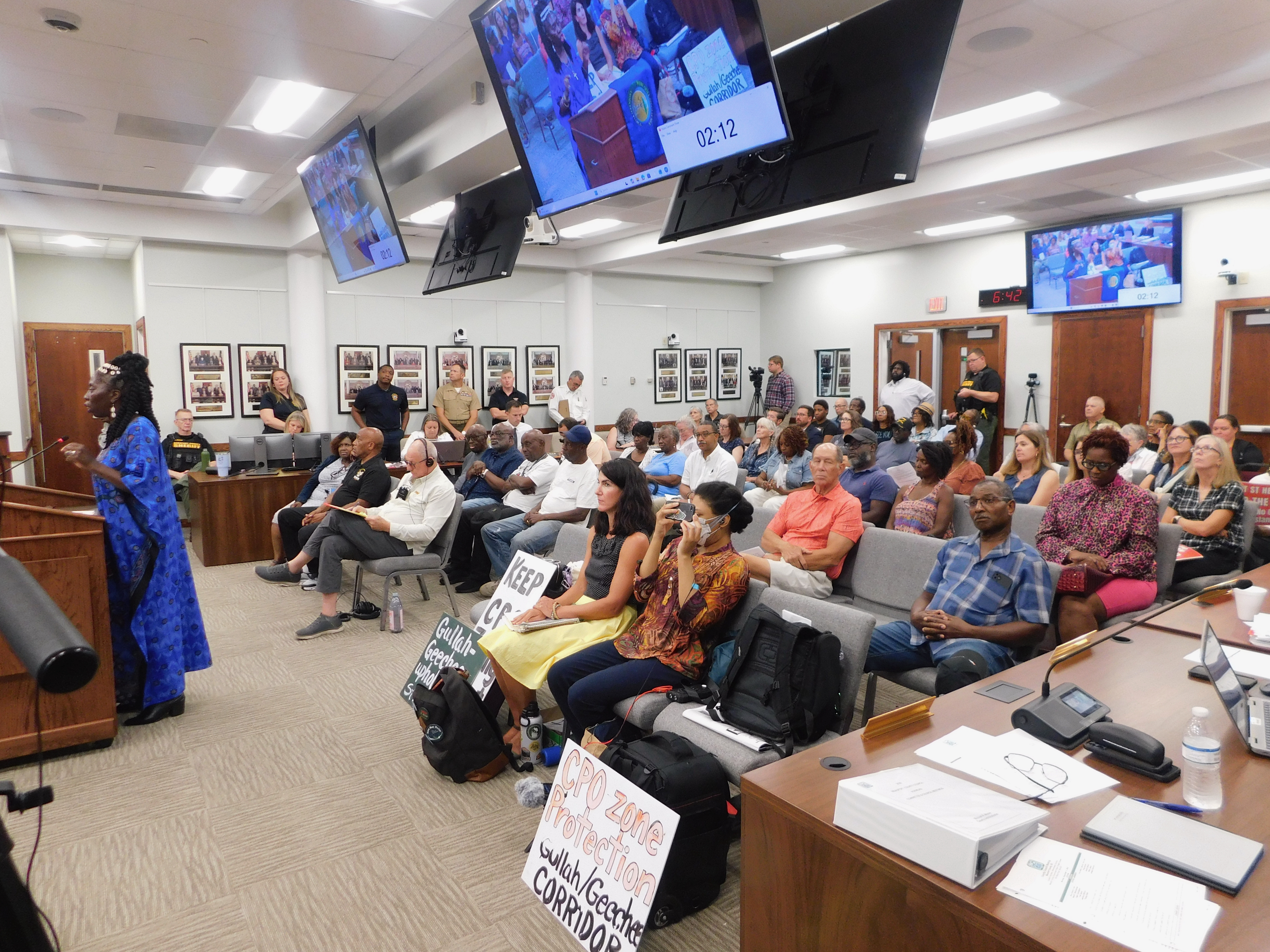
**Beaufort County Council did not vote Monday to remove Pine Island from the St. Helena Island Cultural Protection Overlay (CPO), weaken the CPO, or approve a Pine Island development.**
Beaufort County Council’s September 14 caucus agenda called for a closed executive-session discussion to receive legal advice concerning “Pine Island Property Holdings, LLC and Pine Island GC, LLC v. Beaufort County.” When Council returned to open session, the only announced action arising from executive session involved an unrelated settlement with Nova Industrial Properties.
The community is staying vigilant because on September 2, Pine Island Property Holdings filed a zoning-map amendment seeking to remove approximately 502 acres from the CPO while retaining the underlying T2 Rural zoning. If the land is removed from the CPO, the overlay’s prohibitions on golf courses, resorts, and gated communities would no longer govern those 502 acres. This is the developer’s third attempt to get Pine Island out from under the CPO’s protections. This attempt is being made while the legal fight is also still active. After an earlier federal case was dismissed as moot and that ruling was appealed, the developers filed a separate federal action directly attacking the CPO. That second case was stayed while the appeal proceeds. Native Gullah/Geechees have continued to say that nothing other than the court case or a conservation outcome for that property should proceed at this point. So, the Gullah/Geechee Sea Island Coalition and leaders of the Gullah/Geechee Nation call on people worldwide to continue to sign and share this petition and to come out to the next Beaufort County Planning Commission in support of the CPO:
https://www.change.org/GullahGeecheeCulturalProtectionOverlay
The new map-amendment application is will go before the Beaufort County Planning Commission on *Monday, October 5, 2026, at 6 p.m. at the Beaufort County Administration Building 100 Ribaut Road in Beaufort, SC. Come out and stand up to Protect St. Helena! Uphold the CPO!

************************************************************
Charleston County: the Sol Legare witness tree remains—but watch the roots
There was a meaningful victory at the Charleston County Board of Zoning Appeals, but the precise outcome deserves to be understood.
The case concerned the approximately **40-inch-diameter grand sand live oak** in the Richardson Road right-of-way at Sol Legare—the witness tree Queen Quet, Chieftess of the Gullah/Geechee Nation called on the public to defend in [“Saving de Gullah/Geechee Witness Tree at Sol Legare”](https://gullahgeecheenation.com/2026/07/09/saving-de-gullah-geechee-witness-tree-at-sol-legare/). The tree appears in a 1939 aerial survey and is part of the cultural landscape of the historic Sol Legare community. (https://blackheritagetrees.com/tree-story/the-tree-at-sol-legare/)

The applicant’s earlier request would have removed the tree to create access to proposed lots. That removal request was withdrawn after the James Island Public Service District Fire Department agreed to reduce the required access width around the tree. On Monday, the applicant returned with a redesigned plan: a 10-foot-wide gravel travelway that bends around the oak, rather than removing it.
The BZA unanimously approved the revised variance. The approval allows approximately 41% encroachment into the tree’s critical root zone. It therefore saves the trunk and canopy from immediate removal, but it is not a no-impact outcome. The Board attached three conditions:
1. If the tree dies within three years after construction begins, the applicant must notify zoning staff and provide inch-for-inch mitigation through replacement trees, payment into the County Tree Fund, or a combination of both.
2. Chain-link tree barricades must be installed around protected trees within 40 feet of the disturbance before construction.
3. A certified arborist must monitor and treat grand trees within 40 feet throughout construction, and a tree-preservation plan must be approved before the zoning permit is issued.
The official September 14 BZA recording: https://www.youtube.com/watch?v=CAI1rWtBM2g captures the staff presentation, the revised proposal, the conditions, and the unanimous vote. The result is a community victory because the witness tree remains rooted in place. It is also a reason for continued vigilance. Construction near 41% of a critical root zone must be monitored carefully, and the permit conditions must be enforced.
Unfortunately, the James Island and Sol Legree communities couldn’t pause to celebrate since the marsh and waterways around them are the next threat as other massive tree removals happen in other areas of James Island. Save James Island is asking residents to write the South Carolina Department of Environmental Services (DES) concerning two critical-area dock applications in which amendments to existing dock structures are being requested:
### 1. 1895 Bowens Island Road — HQQ-K36M-NQ6Y2
Applicant: Karen Danielowski
Waterbody: Folly Creek
DES comment deadline was September 17, 2026
The drawings identify an existing **4-foot-wide, 336-linear-foot walkway**. The amendment proposes a 23-by-28-foot roofed pier head, relocation of a 10-by-20-foot floating dock, relocation of a 12-by-12-foot boat lift and a 5-by-12-foot jet dock, and installation of a 3-by-8-foot dock box. The file is identified as an amendment to OCRM-14-372-D. (https://epermitting.des.sc.gov/ext/ncore/external/publicnotice/info/-4164646335553948867/details).
Those that were able to submit comments before the deadline passed, asked DES to evaluate navigation, marsh shading, cumulative dock impacts, public-trust access, water quality, and whether the scale and reconfiguration are the least environmentally damaging practicable alternative.
### 2. 660 Ellis Oak Drive — HQR-2RK5-M6QMY
Applicants: Matthew McCotter Raines and Kristin Reynolds Raines
Waterbody: James Island Creek
DES comment deadline is September 25, 2026
The drawings identify an existing **4-foot-wide, 537-linear-foot walkway**. The amendment would move the existing 10-by-20-foot floater from the flood side to the creek side of the pier head and relocate the existing 12-by-12.5-foot boat lift. Open the official DES notice and use the Comments tab: https://epermitting.des.sc.gov/ext/ncore/external/publicnotice/info/-1182033278809851030/details.
Comments should be permit-specific. Identify the application number, explain how you use or value the affected creek, and request analysis of navigation, marsh and creek-bottom disturbance, cumulative impacts, and effects on neighboring access and the public-trust resource. DES’s own guidance notes that recreational docks over 900 linear feet require a current, agency-certified Critical Area Line; that threshold is not proof that a shorter dock has no impact. (DES critical-area guidance: https://des.sc.gov/programs/bureau-coastal-management/critical-area-permitting/critical-area-permitting-request-critical-area-line
***************************************************************************
Colleton County Council created the legal pathway for data centers
Colleton County Council’s vote was broader—and more consequential—than approval of a single project. At its September 14 special meeting, Council gave third and final reading to a three-part data-center package:
• Ordinance 26-O-07 amended the Colleton County Comprehensive Plan 2030 to recognize “digital infrastructure facilities,” including data centers and battery-energy-storage facilities, as contemplated land uses. (https://www.colletoncounty.org/sites/default/files/uploads/Ordinances/26-o-07-comp-plan-amendments.pdf)
• Ordinance 26-O-08** rewrote the zoning rules, created a Digital Infrastructure Overlay District, replaced the County’s 2025 data-center provisions, and set conditions for data centers and battery storage. (https://www.colletoncounty.org/sites/default/files/uploads/Ordinances/26-o-08-amend-zoning-ordinance.pdf)
• Ordinance 26-O-09** amended the zoning map to place a designated tract around the Mount Carmel Road/Can City Road area into the new overlay. (https://www.colletoncounty.org/sites/default/files/uploads/Ordinances/26-o-09-amend-zoning-map.pdf)
Council did not approve a construction plan, building permit, development agreement, or named data-center campus Monday. It changed the policy, zoning text, and zoning map so qualifying projects can seek approvals. This was all done in spite of the fact that many have said that this is environmental racism as laid out in this petition: https://www.change.org/p/reject-the-data-center-zoning-exception-that-targets-a-black-community and that it would harm the ACE Basin as pointed out in this petition: https://www.change.org/p/stop-the-data-center-from-coming-to-walterboro-sc
Among the new standards, the text ordinance establishes a 300-acre minimum site, setbacks and vegetated buffers, a 65-decibel property-line noise cap, limits on generator testing, and cooling restrictions for projects in nonindustrial overlay areas. It allows data centers and qualifying battery-storage systems as conditional uses in Light Industrial, Industrial, and Heavy Industrial districts. It also partially lifts the moratorium: the moratorium is removed west of I-95 and in already-industrial districts, including industrial land east of I-95. It remains on nonindustrial land east of I-95 while the County undertakes its five-year Comprehensive Plan update.
Many people are confused and outraged by this decision. The question all week was: “Does ‘farther north’ mean outside the ACE Basin?” The answer is “not automatically.”
The newly mapped overlay tract near Mount Carmel Road is different from the approximately 850-acre Eagle Rock/Cooks Hill Road campus south of Walterboro that South Carolina Environmental Law Project has identified as lying in the ACE Basin. Monday’s vote did not approve the Cooks Hill campus, and it did not formally “move” that proposal north.
At the same time, the new ordinance does not draw and permanently exclude the full geographic or ecological ACE Basin. It excludes land zoned RC-1 and RC-2 from the overlay and says overlay areas should be a substantial distance from environmentally sensitive ACE Basin lands. But it directs staff and the Planning Commission to define the ACE Basin more fully during the future Comprehensive Plan update. It also permits data centers conditionally in existing industrial districts. In other words, the promise to protect the ACE Basin is incomplete until a defensible boundary and enforceable exclusion are actually placed in law. The adopted rules still leave potential pathways for data-center development in areas that residents, scientists, or conservation groups may regard as part of the ACE Basin.
The Gullah/Geechee Sea Island Coalition is calling on all supporters to:
• Sign and share the petition: Stop the Colleton County Data Center Project and Protect Rural South Carolina https://www.change.org/p/stop-the-colleton-county-data-center-project-and-protect-rural-south-carolina.
• Ask Colleton County Council and the Planning Commission to map the ACE Basin using ecological and watershed science, not only existing zoning labels; prohibit data centers and large battery facilities throughout that mapped area; require project-level water, energy, noise, air, wetland, and cumulative-impact analysis; and provide full public notice before any development agreement or permit vote.
• Watch for individual site plans, development agreements, utility requests, air permits, stormwater permits, wetland authorizations, and Coastal Zone Consistency reviews. Monday’s zoning package is a gateway, not the last approval.
Other urgent coastal actions
**Canadys gas plant on the Edisto** | A combined-cycle gas-fired power plant at the former Canadys coal-plant site, with stormwater and Coastal Zone Consistency review affecting the Edisto River and ACE Basin. | Attend September 22 at the Walterboro Wildlife Center, 100 S. Jefferies Boulevard: 5–6 p.m. availability session, 6 p.m. public meeting, and 7 p.m. hearing. Submit written comments through September 29. Ask DES to examine cumulative impacts on water, wildlife, nearby communities, and the ACE Basin. (SCELP alert and comment link: https://scelp.org/news/speak-up-for-the-edisto-at-the-canadys-gas-plant-public-hearing
**Crabtree Swamp rezoning in Conway** | A planned-development/destructionment rezoning that could facilitate a shopping center filling nearly five acres of wetlands, including a gas station with underground tanks in a wetland. | The deferred public hearing is expected October 8. Send comments to **planning@ConwaySC.gov** asking the Planning Commission to deny or delay rezoning until wetland, flood, water-quality, and cumulative impacts are resolved. (SCELP alert: https://www.scelp.org/news/proposed-rezoning-threatens-crabtree-swamp)
Also on the Georgia Golden Isles
Comment now on proposed land swaps on Cumberland Island: Mansions don’t belong in wilderness.
In 1972, a Congressional act established Cumberland Island—the Georgia coast’s largest barrier island—as a national park, laying the groundwork for protecting most of Georgia’s barrier islands from development. Although most of Cumberland’s land is owned by the National Park Service (NPS), some remains in private ownership.
Earlier this month, the NPS announced a land swap that in a draft Environmental Assessment which would allow eight new 15,000 square foot homes on eight two-acre lots on the south end of Cumberland Island. Giant mansions do NOT belong on Cumberland Island!
Comments are now open through October 16 🗣️ Learn more and comment at www.OneHundredMiles.org/Cumberland-Swap
*******************************************************************
Monday’s meetings show why headlines are not enough. Coastal protection happens in these details: an executive-session agenda, a map-amendment application, a root-zone percentage, a permit number, a comment deadline, and a definition postponed to a future plan update. Get involved and stay alert! Be an active member of the Gullah/Geechee Sea Island Coalition www.GullahGeechee.net. Join at www.GullahGeechee.biz and follow www.GullahGeecheeNation.com and @GullahGeechee on IG to keep up with updates.
Hunnuh mus tek cyare de root fa heal de tree!
Stand up and fight for our coast with the Gullah/Geechee!
- Posted in: Chieftess of the Gullah/Geechee Nation ♦ Climate Advocacy and Climate Change ♦ Environmental Justice ♦ Gullah/Geechee Events ♦ Gullah/Geechee Health and Healing ♦ Gullah/Geechee Land Ownership & Rights ♦ Gullah/Geechee Ourstory ♦ Gullah/Geechee Riddim Radio Education Links ♦ Gullah/Geechee TV Educational Links ♦ Human Rights ♦ Queen Quet ♦ Uncategorized
- Tagged: ACE Basin, Beaufort County, Charleston County, Colleton County, Conway, CPO, cultural heritage, Cultural Protection Overlay District, Data Centers, Edisto River, Geechee, Gullah, Gullah/Geechee Nation, James Island, Pine Island, Queen Quet, Sea Islands, Sol Legare, South Carolina, St. Helena Island